

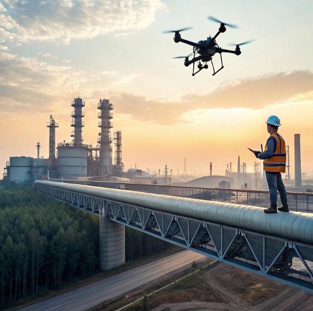
In the push to modernize safety practices, few tools have delivered faster, clearer results than unmanned aerial systems and rapid mapping workflows. Menotti Enterprise has seen how aerial data shortens shutdowns, removes exposure at height, and gives supervisors the visual evidence they need to act decisively—without sending people into harm’s way. What once required scaffolds, manlifts, and spotters can now be captured from a safe distance with precise, repeatable imagery.
This shift isn’t just about cool gadgets; it’s about measurable reductions in exposure hours. By trading clipboards for orthomosaics and photo-realistic models, safety teams can verify guardrails, check tie-off points, and locate loose debris overhead while crews continue productive work below. The result is a new rhythm: quick flights, fast analysis, targeted fixes, and fewer stop-work orders.
Contractors who adopt this approach early discover a surprising advantage—cleaner coordination across trades. Reality capture becomes a shared language that turns questions into annotated images and measurements everyone can trust. With consistent flight plans and standardized outputs, decision-making speeds up, rework drops, and safety margins widen.
Why Drones Belong in the Safety Toolbox
Keeping workers off ladders and away from live edges is the most immediate win. When a roof inspection, façade check, or crane tie-in survey can be performed remotely, you shrink the risk window dramatically. That’s where Menotti NYC Safety Consultants guide teams to focus first: high-frequency inspections that previously demanded at-height access.
Replace risky climbs with repeatable passes
Routine checks—parapet integrity, netting, scaffold planking, or material storage on roofs—become quick sorties that collect high-resolution stills and video from consistent angles. With standardized flight paths, safety leads compare conditions week over week, spotting drift before it becomes danger.
See what a human eye can’t
Thermal sensors reveal moisture under membranes; oblique imagery exposes cracked masonry hidden from the ground. Structured data beats gut feel, and that means faster, more defensible calls when hazards surface.
Keep the work moving
Because flights are short and nonintrusive, you capture evidence without building access platforms or locking down large areas. That friction reduction is why adoption sticks.
Building a Reality-Capture Workflow That Works Every Time
Drones shine when paired with disciplined process. Menotti NYC Safety Consultants organize the workflow into four predictable steps so field teams know exactly what happens next.
Plan: Set targets and no-fly blocks
Define the specific hazards you’re checking—loose façade elements, edge protection continuity, crane pad settlement—and draw a simple site map showing flight corridors and exclusion zones. Note obstacles (cranes, lines, tower hoists) and hours with least wind and foot traffic. Good planning prevents re-flights and keeps neighbors comfortable.
Fly: Standardize altitude and angle
For repeatability, use the same altitude, speed, and camera angles each visit. A typical safety sweep might include a nadir grid for mapping, then oblique passes at 30–45 degrees around façades and roof edges. This structure lets you spot small changes that random shots would miss.
Process: From images to evidence
Turn captures into orthomosaics and quick 3D meshes, then export simple markups: “missing toe board,” “debris at edge,” “loose net tie.” Tag each item with location, severity, and a suggested fix. Clean, visual punch lists get action.
Act: Close the loop on the ground
Share annotated images in the daily huddle, assign owners, and verify fixes on the next flight. When crews see their corrections validated in the next model, participation rises.
Where Drones Cut the Most Risk
Not every task belongs in the air. Focus on locations where a small error could have big consequences and where access is costly or dangerous.
Roofs and setback edges
Scan for unsecured materials, wind-lifted membranes, or blocked drains. Seasonal transitions can hide hazards; regular aerial sweeps spot them early.
Scaffolds and temporary works
From the outside in, evaluate planking continuity, midrails, and netting lap joints. Aerial views catch gaps hidden from deck-level checks.
Tower crane zones
Confirm barricades, laydown discipline, and exclusion area signage before lifts. A quick pre-lift pass reduces radio chatter and last-second changes.
Façade and masonry conditions
Identify spalls, cracks, or loose ornaments that might become falling-object hazards. Pinpoint areas for targeted hands-on verification instead of blanket access.
Pairing Drones With 3D for Better Decisions
Aerial photos are powerful; 3D context makes them unforgettable. When you turn a flight into a georeferenced model, anyone can orbit, measure, and annotate from their laptop. That’s invaluable for cross-trade coordination and regulatory discussions.
Fit-for-purpose accuracy
Safety reviews don’t always require survey-grade precision. For many use cases, a fast, meter-level model is enough to verify protection, staging, and housekeeping. When engineering decisions demand tighter tolerances, fly at lower altitude with ground control and document accuracy targets.
Measurements that matter
Use the model to measure guardrail gaps, toe-board heights, and setback distances in seconds. Precision removes arguments and speeds fixes.
Time travel for trends
Archive weekly models to build a visual timeline. If a condition degrades, you’ll know exactly when and where it started—and which phase triggered the drift.
Integrating Flights Into Daily Routines
The tech disappears when it fits the schedule. Menotti NYC Safety Consultants coach teams to wrap flights into existing rhythms so it feels like part of the job, not a special event.
The ten-minute morning sweep
Before crews hit the deck, a pilot runs a short route over high-risk areas. Findings get two minutes in the huddle with annotated stills. Priority items receive immediate owners.
Pre-crane and post-storm checks
Fly before critical lifts and after high winds or heavy rain. Rapid confirmation prevents false starts and catches emergent hazards.
Weekly compliance snapshots
Use consistent angles to produce a “compliance strip” of key controls: edge protection, access ways, debris nets. Hang printouts on the notice board to make progress visible.
Privacy, Airspace, and Neighbor Relations
Urban airspace is sensitive. Respect for people and rules keeps the program sustainable.
Clear optics policy
Limit capture to the site footprint and sky above. Mask neighboring windows in outputs, and retain data only as long as needed. Communicate guidelines to pilots and supervisors alike.
Fly legal, fly polite
Confirm airspace class, temporary flight restrictions, and local rules. Share a simple notice with adjacent buildings before regular flights. A small courtesy call defuses most concerns.
Document permissions and training
Keep pilot certifications, equipment logs, and flight plans in a single folder. When questions arise, answers should be immediate and complete.
Choosing the Right Tools Without Overbuying
You don’t need a hangar of gear to start. Begin small, then scale deliberately.
Aircraft
A compact quadcopter with obstacle sensing and a stabilized 20MP sensor covers most safety use cases. Add a second battery set for continuous rotations.
Sensors
Start with RGB. Add thermal only if roof moisture or electrical checks are frequent. Specialized sensors make sense when they answer recurring questions.
Software
Pick one workflow that produces orthomosaics and quick meshes with easy annotations. Speed beats complexity; crews act on pictures, not on manuals.
Measuring Impact That Matters
If it doesn’t move the numbers, it’s theater. Track the leading indicators that show exposure shrinking.
Exposure hours
How many worker-hours at height were avoided because a flight delivered the evidence? Convert canceled climbs into time saved.
Time-to-fix
Measure hours from detection to closure. Visual clarity should shorten that cycle; if not, refine how findings are routed.
Repeat conditions
Count how often the same issue reappears. If repeats persist, adjust storage practices, sequencing, or trade coordination.
Getting Started in 30 Days
Week 1: Pick two high-value use cases—roof edges and scaffold checks. Draft simple flight plans and a one-page privacy policy.
Week 2: Conduct baseline flights and produce annotated stills and a quick model. Share in the huddle; assign owners.
Week 3: Tune angles, reduce noisy captures, and add a pre-lift sweep before crane operations.
Week 4: Report results: exposure hours avoided, time-to-fix improvements, and two layout changes driven by aerial evidence. Decide whether to expand to façade passes or laydown yard monitoring.
Conclusion
Drones and rapid reality capture let safety leaders see more, risk less, and act faster. When flights are standardized, outputs are simple, and findings route straight to the people who can fix them, the program becomes a quiet engine of prevention. Menotti Enterprise helps teams design these workflows so pilots, supervisors, and trades stay aligned on what to fly, what to measure, and how to close the loop. With steady routines and respectful airspace practices, you’ll replace risky climbs with crisp imagery, turn arguments into measurements, and keep progress moving—proof that modern visibility is a safety control in its own right, delivered by Menotti Enterprise.
Menotti NYC Safety Consultants bring structure and acceptance to this modernization—aligning airspace rules, training pilots, and integrating outputs into daily huddles so the effort scales gracefully across phases and buildings.
As projects grow taller and schedules tighter, the ability to capture truth without climbing for it becomes a decisive advantage. With the right mix of planning, flight discipline, and clear communication, you’ll reduce exposure, accelerate fixes, and build a record of proactive control that stands up to scrutiny—led and sustained by Menotti Enterprise.