



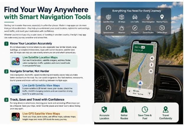
A person’s travel today is not just about knowing the road to the destination. Users frequently want to know more about an unknown region before they depart, check traffic, locate local of interest, track location, create a map of commonly used routes or keep maps on hand when mobile internet is not available.
This is why modern map apps have grown to become more comprehensive travel apps. Satellite images can give users a sense of what a location looks like, 3D maps can give them more context about the place, traffic data can facilitate route planning, and GPS functionality can help users track their location throughout a trip.
However, all these features are different for different users. Traffic and fast route planning can be a commuters main concern. A visitor to a new city may prefer to check out satellite views, current location, places of interest and weather. The savings of routes, offline maps, GPS tracking and terrain information can be important for someone traveling the road.
The three Android apps below take a slightly different tack at these needs.
Explore Destinations BEFORE You Arrive.
One of the most valuable additions to digital mapping is a possibility to ‘visit’ a location without doing so in person.
A standard map might include street names and road links but it doesn’t always give enough visual detail of what’s around them. Whether it’s a new hotel, hospital, office, shopping area, tourist destination, or neighborhood, viewing the place from an aerial perspective can make it easier to digest.
Live Earth Satellite View Maps places a high emphasis on the visualization aspect, but also offers route planning and driving options as well.
The app features Satellite View, giving the user a view of a road, building, neighborhood, landscape and the surrounding area from above. This may be helpful for travelers who want to have an idea of the destination’s layout before they go there.
It also provides 3D Map and 3D Terrain. These views can serve as a fresh approach as one explores cities, hills, roads and unfamiliar places. Sometimes such a schematic view of buildings and terrain will be easier to understand than a flat road map.
Another important step is to plan the route. The Route Planner can be used to check the route prior to leaving. This allows them to get to know the roads and the direction of travel without having to learn them as they drive along.
A trip may also rapidly change because of the traffic. The Traffic Map allows the user to check the road conditions before departure. It could be especially helpful for commuters during rush hour, for people entering new cities to get a heads up on where congestion may be.
The app also has Address Finder and Distance Measure. Address Finder is useful when you know the exact address of the destination you are looking for and want to confirm its location, and Distance Measure is useful in figuring out distance between selected points.
Repeated searches can be saved for those who visit the same addresses regularly, with details from recent trips shown.
EV Charging Stations are also available for those drivers who want to take a longer trip or venture outside of a familiar area of the country.
The app can be useful beyond just satellite exploration, with the addition of Nearby Places, Voice Navigation, Speedometer, Speed Alerts, Compass and Weather.
Use Live Satellite Location Maps to determine your location.
Sometimes the biggest problem is not getting directions. It is determining the exact position of a person.
This is frequently in areas that aren’t familiar to you. You might be close to the end but may not know which road, building or entrance is the right one.
Live Satellite Location Maps by VertixSoft is based on location discovery and everyday travel products.
The app features Current Location that can pinpoint the user’s location and Address Finder to search addresses.
It also has Satellite View and 3D Map.
These projections offer a more visual representation of an area, sometimes unavailable from a road map, and are helpful to users.
The app has Voice Navigation for navigation.
Having directions read aloud can be helpful in driving to save eyes on the phone screen.
The app also has a Traffic Map feature that could be useful for users to see if roads are congested before they even head out.
There is also a Speedometer and Compass available for drivers and travellers.
The Tourist Places feature might be useful to the people who like exploring new places. While traveling in a new city, it might give you suggestions on where you can go for a sightseeing.
An additional handy capability is Weather Updates.
Even a short trip can be influenced by the weather conditions and so checking the forecast before leaving can be useful in planning.
The app also has some more useful features like World Clock, Currency Converter, STD Codes, Country Codes, QR Scanner, Sound Meter and Sensor Info.
Some of these resources are particularly helpful for those travelling abroad. For instance, World Clock can be useful in dealing with other time zones, and Currency Converter can be helpful to understand prices on another currency.
It can also be handy for individuals who don’t want to download individual apps for every thing.
You can Get Live Satellite Location Maps if you are primarily interested in getting current location, satellite views, address search and travel utilities.
Track Your Trips – Live GPS Satellite View Maps: Monitor trips in real time with live GPS satellite view maps.
Sometimes getting from one place to another is the easy part.
You might consider saving the route, remembering where you went or even using a map when there is limited internet connectivity.
Live GPS Satellite View Maps by The Apps Land is more about tracking a route, saving a journey and going offline.
Self Tracking is one of its major components.
This can assist users to follow their movement during walking, driving or travelling in an area they are not familiar with.
The app also has Saved Tracks so that you can save a trip for later.
This can be helpful if you find a path you want to take again or just want to remember what path you took.
The app also provides Route Navigation and Saved Routes.
Users can save the places they go often so they don’t have to look for the same location again and again.
One of the most useful tools is Offline Maps.
Access to mobile internet is generally good, but can be spotty when on the go or in more rural or remote locations. It may then be helpful to have maps available offline as an alternative.
If you are in a bigger city there is also a Subway Map.
The subway information can be interesting in a new town, and simplifies the arranging process.
Live Traffic allows drivers to see the condition of the road and the built-in Speedometer will display the speed.
For those who like to look at it, the app also has Earth Map, 3D Earth and Height Map.
The use of the Height Map can be particularly interesting if you have mountains, terrain or areas where elevation is important.
The app has Location Finder for location search.
There’s also Area Finder and Saved Area which can be helpful if you’re using a larger area than just an address.
Tourist Places allows travellers to find interesting places and Weather to get a weather forecast before travelling.
Other tools like Compass and STD Codes offer additional everyday functionality.
To gain tracking and saved routes, offline maps and GPS based navigation features, you can Install Live GPS Satellite View Maps.
What type of App do you need for your trip?
Navigators are used in a wide variety of ways.
They don’t care so much about traffic, just route planning. Some like to use satellite imagery, location tools or maps that can be used offline.
Live Earth Satellite View Maps is better for users looking for satellite exploration, 3D terrain, route planning, traffic information, EV charging points and driving tools.
Live Satellite Location Maps is more geared towards current location, satellite views, address finding and additional travel aids.
Live GPS Satellite View Maps is ideal for those who prefer route tracking, saving of journeys, offline maps and GPS.
This will be dependent on your usual mode of transport.
Traffic can be the most important consideration for someone who commutes daily. When a visitor visits a new city, he might choose the satellite maps and the tourist destinations. Routes and offline maps may prove helpful to someone who is making a long road trip.
Maps are no longer simply used for finding the quickest road between two locations. They can be used to explore, plan, learn about the world around you and to keep all useful travelling information together.